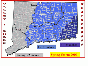
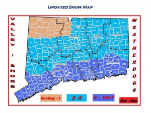
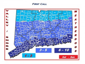
Unpredictable Snow Storm on the way

**** First Call Snow Map *****

We say First Call because god only knows this storm will bite us in the butt and make us look like fools. But as of now this is what we are seeing. Could it be less?? Yes… could it be more?? highly unlikely. These totals are on the slightly higher side due to the complexity of this storm.

Timing is still a tough call but most of us will be asleep when the heaviest if you want to call it that of the snow will fall. It looks to last into the morning hours in the West and Central parts of the state. It holds out a bit longer in the East.

School delays will be expected especially in Central and Eastern CT. There may be some delays in the West towns but only as a precaution. Look for cancellations in Eastern CT and maybe some over protective school officials in Central CT.

This will be the heavy wet type snow so we could see some power lines and tree branches come down especially in Eastern CT causing some power outages.

Thats all for now we will follow up later on today. Enjoy the Sun while it lasts. It is much cooler outside and the temps will drop as the day goes along.

Please follow our weather page on Facebook

Valley Shore Weatherdogs

Tom and Kevin

Is winter over?? The Weatherdogs chime in…

That maybe the questions asked to us Weatherdogs over the next few days but our answer is a big fat NO! You will start to see a lot of hyping and chatting going on with other weather sources about what some may call a huge storm for next week… but this is what we can tell you as of today.

A model consensus and almost total agreement as of this morning is showing us that all the ingredients for what could potentially be a good sized East Coast Storm for next week will be in place. Now before we get bombarded with questions it is way too early to do much of any type of forecast. There will be changes every model run over the next 5-6 days. We will have a nice little break in the winter weather action to recharge our batteries. For our landscaping and DOT friends take these next 5 days to rest up, fix and clean up any equipment that might need it.
Next Wednesday and Thursday is the time frame as of today. If we were to show you the model output for snow totals it would be an injust and not fair. Just know we are closely monitoring the potential for a storm mid to late next week.
For all our weather geek friends… yes that’s you.. yes you the one who just stopped reading our post and went and looked at the model snow fall potential please take those model images for a grain of salt. There will be plenty of changes to those pretty colors on the map in the next 5 days.

We are closely monitoring the potential for a storm. Please follow us on Facebook at Valley Shore Weatherdogs for more up to date information and posts!

Have a great day!    Tom and Kevin

Dangerous Cold

Good early Saturday morning…

These are some of the warning headlines from the NWS this morning. This will be by far the colds temps we have seen in the last 5-10 years. Heed the warnings… the only good thing is it only lasts for 36 hours and then we will see this polar air exit stage right.

Lots of model agreement and disagreement for the Early week storm. Hopefully by late tonight or early tomorrow we should have a better idea of what will happen.

Stay warm!!  Tom and Kevin

Follow us on Facebook at Valley Shore Weatherdogs 

Updated Snow Map


A move North… just as we thought all along!!

As you can see we have posted a updated snow map.. It is not that far off from our first call map from the other day. We felt all along this storm was going to move back North. Does it have a chance to move south again?? Yes but we are sticking to our guns. The only real change was for the NW Hills.. you might be left out of this storm but on the other hand a slight move more to the north and you are back in the game!

This is going to be a coastal snow storm and we just dont just mean snow we are talking very gusty winds and tidal flooding too. Lets be thankful the winds will be coming from the North East and not the South East because then we would have some grave concerns for major flooding.

Time line… Snow starts along the coast Saturday morning around the 6am to 9am time frame, Hartford around 11am or so. This looks to last into the morning on Sunday.

We will post a final snow map later tonight….

Please follow us on Facebook for more up to date posts.  Valley Shore Weatherdogs

Weatherdogs ***First Call Snow Map***

This is our feeling as of this afternoon. Can this change?? Yes and it probably will. Will it go up? Or will it go down?? That is what we need to see over the next 24-36 hours. We are speaking a mere 25-50 mile shift North or South to make these numbers go up or go way down especially for those of you in Northern CT. There is a chance you see almost nothing thats how thin of a line it is. Timing as of now is Snow moves in Saturday morning and ends Sunday Morning. Again Subject to change!
The winds and coastal flooding may turn out to be a bigger issue than snow fall.

Again this is our First Call Map this is NOT our set in stone forecast! We will continue to monitor the data and post what we are seeing.

Please follow us on Facebook for more up to date information! Valley Shore Weatherdogs

Tom and Kevin

Weatherdogs Storm Update

Good Wednesday morning Doing It Local fans!  Sorry for our absents as of late but we have not forgotten about you!  So did you hear about a potential storm on the way??? For those of you that follow us on Facebook know we are monitoring this storm very closely!  So what do we know as of this morning??

The weather models currently are working their magic to give us a outcome that will satisfy everyone. Some show a moderate snow storm for us while other models say wait a minute not so fast.

Our feeling as of this morning is we will see snow here in CT. How much is yet to be determined. The time frame is still up in the air as well but we feel a early Saturday morning start and lasts into Sunday morning.

For our coastal friends we need you to heed this warning…. with the full moon in place and a large storm off the coast throwing wind at us there will be coastal flooding and beach erosion. If you live in an area that floods or if you are near an area that comes close to flooding your property the time to prepare is now. Bring what ever might be under water to higher grounds. We could easily see high tide 4-6 feet higher than normal depending on the storm track.

We are closely watching the data as it comes in. We will do our best to update on here as often as we can. For more up to date info please follow us on Facebook at Valley Shore Weatherdogs or on twitter at ctweatherdogs.  Have a great day!

First Winter Storm on our door steps..how bad will it get??

Good Monday afternoon everyone…. ok lets get into our first real winter threat of the season. If we were in February we would be laughing at this storm right now but because it is the first potential threat we are all excited and worried!!

Its not looking too bad… yes it will be slick come morning and yes extreme northern parts of the state may see a inch or so of snow but trust us this will all turn to rain by mid to late morning.
The colder air to our North did not move down as far south as models were showing us late last week. Ok its cold out today but can we really complain??? It warms back up a bit come mid week!

Ok so the timing… if you realllllllly want to see some snow you might have to be up around midnight tonight. That is when some flakes might start to fly. We feel everyone should see some form of snow to start with and yes the ground will be some what cold enough where it wont melt on contact. For the Southern half of the state any snow will quickly change over to a snow/sleet and freezing rain combo before it turns to all rain by early morning. Even though it will turn to rain there will be slick spots on the roadways.
Northern CT… lets say north of Hartford the snow sticks around a bit longer… maybe a coating to a inch or so if we see some heavy pockets. North of Hartford will gradually see the change to that mix and then to all rain. If you are looking for big snow head up to Northern Maine for this storm where they will see some much welcoming snow for the ski resorts!

That’s it for now…  follow us on Facebook at www.facebook.com/valleyshoreweatherdogs for more quick updates as the storm draws closer.

Have a great afternoon and be safe!

Tom and Kevin

Holiday Week Forecast! Record Warmth!!

Here is a sneak peak at the upcoming week…

A little unsettled especially Tuesday through Thursday morning. Record warmth for Christmas eve and not to shabby for Christmas day with lots of Sun and temps in the 50’s!

We will update on the rain in the coming days and we are looking long range…will there be snow in our future??? Stay tuned!

Please follow us on Facebook…   www.facebook.com/Valleyshoreweatherdogs

Have a safe start to the week!

Tom and Kevin

Exit mobile version