The City of Bridgeport EOC is monitoring the potential storm tracks for tonight into tomorrow, especially with the slight risk of Flash Flooding. Here is an update concerning the flash flooding threat for late tonight and Friday morning.
As low pressure approaches from the Mid-Atlantic region late tonight and passes over or just south of New York City and Long Island on Friday, rain could become heavy at times from latetonight into Friday morning. Rainfall of at least 3/4″ to 1 inch is expected, with locally higher amounts up to 2 inches. Isolated higher amounts are possible if training of any heavier showers occurs over the same area.
Overview:
WHAT: SLIGHT RISK of Flash Flooding
WHERE: Northeast New Jersey, Lower Hudson Valley, Southern CT and Parts of Long Island
WHEN: Late tonight and Friday Morning
Potential Hazards and Impacts:
Flash Flooding: A basin average rainfall of 3/4″ to 1″ is expected with up to 2″ possible in localized spots . There is still some uncertainty as to where the heaviest rainfall bands will set up, so not all places within the watch area may experience flooding. However, it will not take much additional rainfall to cause flooding in locations hard hit on Tuesday, and the heavier rainfall rates and total amounts could cause urban and highway flooding during the Friday morning rush. Minor small stream flooding is also possible, especially along small streams in northeast New Jersey.
- Rainfall rates of 1/2 to 1 inches/hr are possible
- Locally heavy rainfall will lead to areas of urban and poor drainage flooding.
- Minor flooding along quick responding rivers/streams is possible.
- Isolated thunderstorms moving over the same area will result in flash flooding.
A Flash Flood Watch is in Effect..
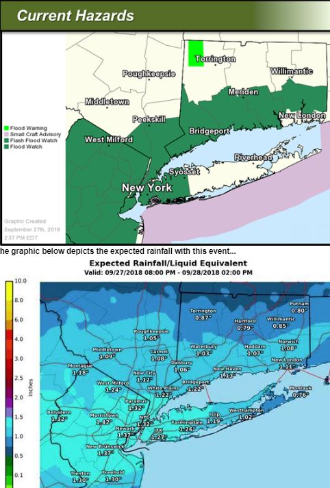
The graphic below depicts the expected rainfall with this event…
CONFIDENCE OR FORECAST SCENARIOS:
There is moderate confidence in showers and thunderstorms developing tonight, but it is uncertain how widespread the threat for flash flooding will be. Any heavy rain that falls over already saturated ground increases the potential for Flash Flooding.
We urge all residents in low-lying and poor drainage areas to keep a close eye on the weather updates and if possible to move their vehicles to a higher location just to be safe. Rainfall amounts are not expected to be in the range of Tuesday’s event however; with the ground and water tables higher there still is a chance for flooding so please stay safe and prepared.